  NTT DATA Corporation, a global IT solutions provider, and MapmyIndia, India’s leading digital mapping, navigation and location technology company, announced today that they have partnered to develop India’s first large-scale 3D map datasets, named AW3D India. The joint undertaking will deliver unrivaled digital-elevation datasets on a fast, cost-effective basis, combining NTT DATA’s expertise and international experience in mapping and 3D technologies with MapmyIndia’s two-plus decades of experience in mapping the Indian terrain.
What is AW3D?
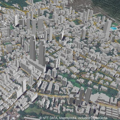
AW3D® is the world’s most precise, pre-produced global series of digital-elevation models covering all land spaces with five-meter resolution. AW3D also provides high-resolution 3D maps across the globe with up to 0.5m resolution. AW3D was developed and is marketed jointly by NTT DATA, a world leader in elevation data, and the Remote Sensing Technology Center of Japan (RESTEC). To date, AW3D models have been used in 500 projects in more than 70 countries, mainly emerging countries of Asia and Africa, for infrastructure development, disaster prevention measures, and much more. Users of AW3D India will benefit from up-to-date, highly detailed 3D datasets covering extensive areas of the Indian subcontinent.
“Through our collaboration with MapmyIndia, we look forward to establishing a leading position in India’s 3D mapping market,” said NTT DATA Senior Vice President Shinichi Usui. “Building on MapmyIndia’s local strengths, we will offer 3D datasets that enable our Indian customers to develop sustainable and future-capable businesses. This will be an important step in NTT DATA’s plan to drive the global market for 3D mapping.”
“It has been our endeavor to make available to the Indian consumer the best of mapping and location technology,” said MapmyIndia Executive Director Shivalik Prasad. “I am happy that a leading company like NTT DATA has joined forces with us to develop AW3D maps for India, which are some of the best 3D map datasets in use across the world. With MapmyIndia’s new collaboration, Indian businesses will have access to the most accurate and comprehensive 3D maps of the country, which would make them even more competitive in domestic and international markets. These maps will also help the Indian government and its agencies to better plan and execute infrastructure development, resource allocation, disaster mitigation and prevention, and more.”
Coverage and Benefits
To develop AW3D India, NTT DATA’s 3D mapping algorithm will be combined with MapmyIndia’s advanced mapping technology. Initially, 3D building data will be developed for tier-one cities and then gradually extended to other cities based on market demand. The datasets will be extremely useful for a wide variety of segments in the Indian economy, including telecom, automotive, construction, insurance and government. AW3D for India’s 3D maps will enable users to make fast, informed decisions for undertakings such as 4G/5G network planning, navigation, insurance risk mitigation and smart city planning.
NTT DATA’s rich background in building elevation products began with the introduction of AW3D Standard in 2014. AW3D India will be one of the newest additions to the NTT DATA Elevation portfolio, which also includes high-resolution AW3D Enhanced products. MapmyIndia produces India’s most comprehensive, exhaustive, detailed maps that offer unmatched coverage – 12.50 million unique destinations (points of interest), expanded coverage of over 5.2 million kilometers of road network, 8,000 plus cities at street level with house address-level data for more than 200 cities, 600,000 villages and 3D and 2D landmarks in 75 cities. MapmyIndia is deeply integrated with various sectors and government agencies of India. Many leading global companies already use MapmyIndia maps, which will be a strong competitive advantage for the collaborative undertaking with NTT DATA. |